April 30, 2020
Five ways researchers find whales in the open ocean
Estimated reading time: 0 minutes
BY: Rachelle Naddaf
North Atlantic right whales are one of the most endangered whales on the planet with only about 360 individuals left. And while they can grow to 15 metres in length – both longer and heavier than an average city bus – right whales have proven to be tricky to find in the vastness of the ocean.
With so many advancements in technology, we are gaining more insight into the lives of these majestic whales and are able to find and track them throughout the north Atlantic Ocean and the Gulf of St. Lawrence. It is important for researchers to know where the whales are in order to implement measures designed to protect them from the threats of entanglements in fishing gear and vessel strikes.
Here are a few of the incredible techniques and technologies that are used to find North Atlantic right whales, and other marine mammal species:
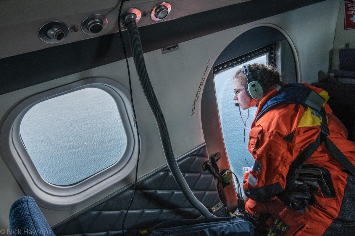
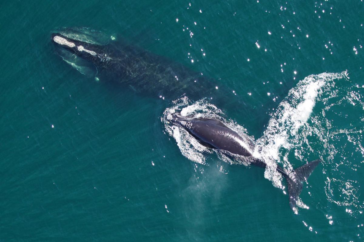
1. Aerial Surveillance
Aerial surveillance is conducted by survey planes which fly in a grid-like pattern (called tracklines) to ensure they collect as much information as possible. Observers on board these survey planes have one main objective – to locate and document whales. Once an observer sees a whale, they record information including the position, number of whales present, dive times, behaviours and evidence of any entanglement or injuries. They are also responsible for taking a photograph of the whales to help identify them. In the case of North Atlantic right whales, each individual has a unique pattern of thick grey or white patches, called callosities, on their bodies, allowing researchers to identify individuals by their unique patterns and markings. Identifying right whales through the use of aerial surveillance is central for triggeringprotection measures into affect once their presence is documented. Unfortunately, using aerial surveillance to find whales can be like trying to find a needle in a haystack and requires a little bit of good luck and impeccable timing.
2. Acoustic hydrophones
Acoustic hydrophones are underwater devices that detect and record sounds in the ocean. Most hydrophones produce a small electrical current when they are subjected to changes in pressure caused by underwater noises, like whale songs or ship traffic. Researchers can program hydrophones to detect specific sound frequencies and implement classification systems, which means they can filter out some sounds and listen for specific whale species. Once a hydrophone detects sound, it amplifies and records the electrical signals produced, identifies the species based on a series of characteristics of the sound and reports the findings via satellite to a database. Acoustic hydrophones can be moored to one location or can be free floating, passively drifting with ocean currents. While a single hydrophone can pick up noises in the ocean from any direction, multiple hydrophones can also be positioned in an array, often tens to hundreds of kilometres apart, in order to gather data with a greater degree of sensitivity and accuracy. Similar to aerial sightings, an acoustic detection of a right whale in Canadian waters will trigger measures to protect them.
3. Gliders
Gliders are autonomous underwater vehicles (AUVs) that are used to track and identify animals and understand key characteristics of the ocean environment. They are equipped with acoustic hydrophones and other sensors that monitor factors like water temperature, salinity and ocean currents. The combination of all of these sensors allows researchers to develop a broader, more complete picture of what is going on in the ocean by understanding the whale in its environment. Gliders can travel far distances over long periods of time, allowing them to go places that are impractical to send people and at a fraction of the cost. They can be pre-programmed to travel to waypoints and can collect data for days, weeks, or even months. The only trouble is that sometimes their batteries may die before the glider is recovered, making them incredibly difficult to find. Fisheries and Oceans Canada (DFO) uses underwater acoustic gliders to identify the location of North Atlantic right whales.
4. Snotbots
Snotbots are custom-built drones that are designed to fly through the blow of a whale and collect exhaled “snot” on small petri dishes. A whale’s snot carries incredibly valuable biological information – including their DNA, stress hormones, pregnancy hormones, bacteria and other indicators of the animal’s health. Although not exactly a tool used to locate animals, these snotbots are important for gathering information on right whales with minimal disturbance to the whales. Especially when working with endangered species, it is critical that unnecessary stress is not added to the animals while conducting research. Scientists are using snotbots to determine the health of North Atlantic right whales when they are in the Gulf of St. Lawrence.
5. Infrared technology
Infrared technology is a newer tool being used to detect whales and will be tested on right whales in the summer of 2020. Since finding whales at the sea surface can prove difficult, using thermal imagery cameras to pick up infrared light or “heat” can help to identify whales, especially during hours of darkness. Infrared technology can detect the difference in temperature between an animal’s skin or breath and the surrounding water or air. While a whale’s blubber traps in most of their body heat making it somewhat difficult to detect using infrared cameras, there are areas where the blubber is thinner like on their fins, tails, and around their blowholes. Additionally, every time a whale surfaces to breathe, they release heat from their blowhole which stands out clearly against the background of the cold Canadian waters. While there are some environmental factors that can affect the efficiency of thermal imagery cameras, including fog, precipitation, solar reflection of the sea and wave action, infrared cameras still prove to be an incredibly useful tool to detect whales.
As technology continues to advance, so does our ability to find whales and put appropriate measures in place to protect them. One new and emerging technique is the use of detailed, high-resolution satellite images to detect whales. Even when taken almost 640 kilometres above the ocean’s surface, these high-resolution satellite images are able to distinguish characteristic features of large whales, including their flippers and tails. Thus far, fin whales and grey whales have proven the easiest to find and identify due to the contrast of their body colour against the colour of the ocean’s surface. Researchers are working hard to figure out ways to use this technique to detect dark coloured right whales – and let’s just say things are looking promising.
To get comprehensive up-to-date information about North Atlantic right whale sightings in Canadian waters, check out this whale sightings map. You can also visit Oceana.ca/RightWhaleToSave to learn more about Oceana Canada’s work to save right whales and how you can take action to ensure these whales remain an icon of the north Atlantic Ocean for generations to come.
